This article has been reviewed according to Science X's
editorial process
and policies.
Editors have highlighted
the following attributes while ensuring the content's credibility:
fact-checked
proofread
Ocean wind wave model upgrade improves the forecasting system
by European Centre for Medium-Range Weather Forecasts (ECMWF)
Normalized change in temperature forecast root-mean-square (RMS) error, measured against own analysis, showing the impact of all wave-model-related changes, for combined winter and summer seasons. Cross-hatching indicates statistical significance at a confidence level of 95%. Blue areas indicate a reduction in RMS and hence a beneficial impact. Credit: European Centre for Medium-Range Weather Forecasts (ECMWF)
In the next upgrade of ECMWF's Integrated Forecasting System (IFS), changes in the ocean wind wave model component will be implemented that improve forecasts.
The improvements concern the representation of air–sea momentum exchange under strong wind conditions, and the role of waves in heat and moisture exchange. They lead to better forecast scores, for example for temperature in the atmosphere.
The upgrade from IFS Cycle 48r1 to 49r1, which includes many other changes, is scheduled to take place in October 2024.
Air–sea momentum exchange
ECMWF's Earth system model includes an ocean wind wave component (ECWAM) to represent how the generation of waves by wind modulates the exchange of momentum between the atmosphere and the ocean.
It has recently been found that there is a decoupling between near-surface winds and the ocean surface for strong wind situations. This results in a reduction of the transfer of momentum from the atmosphere into the wave fields.
Based on this evidence, we have been adapting the model to reduce the drag coefficient (Cd), which relates the resistance of the water surface to wind, for high winds. The latest revision, which was only applied to 10 m winds above 33 m/s, was implemented in 2020.
Normalized change in two-meter temperature forecast root-mean-square (RMS) error, measured against own analysis, showing the impact of sea-state-dependent heat and moisture fluxes for the combined winter and summer seasons. Blue areas indicate a reduction in RMS and hence a beneficial impact. Credit: European Centre for Medium-Range Weather Forecasts (ECMWF)
In IFS Cycle 49r1, a more physically based model that does not require a fixed wind threshold will be introduced. That way, changes in the transfer of momentum from air to waves are already felt for winds below 33 m/s.
For low wind conditions (< 10 m/s), the new approach behaves generally like the previous one. It has, however, a lesser decrease for winds above 40 m/s.
Heat and moisture exchange
Wave-induced motions in the air lead to an enhancement of the heat and moisture exchange between the ocean and the atmosphere. To capture this, in IFS Cycle 49r1 the way the heat exchange coefficient (Ch) varies with wind speed has been adapted.
An added sea-state dependency means that the heat exchange will tend to be increased compared to previous IFS cycles, especially for storm wind conditions.
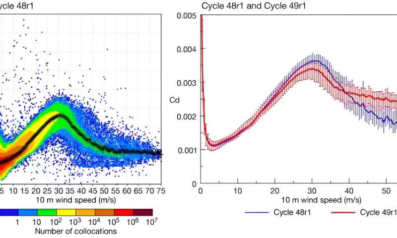
Drag coefficient (Cd) over the North Atlantic and corresponding 10 m wind speed during Hurricane Lee. Forecasts from 8 September 2023, 00 UTC, were performed at the experimental TCo2559 resolution (4.4 km). Results are shown aggregating all hourly forecast steps from 12 to 72 hours for Cycle 48r1, with black crosses showing mean Cd values for given wind speeds (left), and Cycle 48r1 (blue) and Cycle 49r1 (red) for the binned mean values and error bars for one standard deviation on either side of the mean (right). Credit: European Centre for Medium-Range Weather Forecasts (ECMWF)
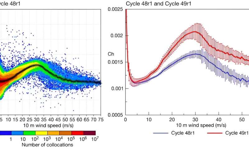
Heat exchange coefficient (Ch) over the North Atlantic and corresponding 10 m wind speed during Hurricane Lee. Forecasts from 8 September 2023, 00 UTC, were performed at the experimental TCo2559 resolution (4.4 km). Results are shown aggregating all hourly forecast steps from 12 to 72 hours for Cycle 48r1, with black crosses showing mean Ch values for given wind speeds (left), and Cycle 48r1 (blue) and Cycle 49r1 (red) for the binned mean values and error bars for one standard deviation on either side of the mean (right). Credit: European Centre for Medium-Range Weather Forecasts (ECMWF)
Other changes
In Cycle 49r1, some other ocean-related changes will also be implemented. They concern the way we parametrize the sea state in areas partially covered by sea ice, and the use of altimeter wave height data.
In addition, the wave model will be run on the same grid as the atmospheric model, simplifying the data exchange between the two systems.
Impact
When all the changes are taken together, there is a clear improvement in atmospheric temperature scores. These are shown for 24-hour forecasts and 120-hour forecasts compared to ECMWF's best estimate of temperature (the 'analysis' of temperature) throughout the atmosphere.
Near-surface temperatures are improved as well.
There are also positive effects on wave height forecasts compared to ECMWF's analysis and to observations.
Provided by
European Centre for Medium-Range Weather Forecasts (ECMWF)
Citation:
Ocean wind wave model upgrade improves the forecasting system (2024, June 24)
retrieved 24 June 2024
from https://phys.org/news/2024-06-ocean.html
This document is subject to copyright. Apart from any fair dealing for the purpose of private study or research, no
part may be reproduced without the written permission. The content is provided for information purposes only.


 error, measured against own analysis, showing the impact of all wave-model-related changes, for combined winter and summer seasons. Cross-hatching indicates statistical significance at a confidence level of 95%. Blue areas indicate a reduction in RMS and hence a beneficial impact. Credit: European Centre for Medium-Range Weather Forecasts (ECMWF)")
 error, measured against own analysis, showing the impact of sea-state-dependent heat and moisture fluxes for the combined winter and summer seasons. Blue areas indicate a reduction in RMS and hence a beneficial impact. Credit: European Centre for Medium-Range Weather Forecasts (ECMWF)")