


Located in northeastern Brazil, the Caatinga, with its shrublands and dry forests, is seen by many as poor in biodiversity. As a consequence, the region receives little investment for conservation actions. Experts say, however, that with more than 900 species of plants and animals, the biome is the largest and most diverse among the world’s seasonally dry tropical forests. It is also the only wholly Brazilian biome and one of the least-studied regions on the globe.
Distributed along 47,100 fragments, around half of the Caatinga vegetation remains – and constant water stress makes it deeply vulnerable to climate change. Now a recent study points out that even these remaining non-deforested areas are severely threatened by human action accumulated over decades and centuries. Authors call the effect chronic anthropogenic disturbance, and note it is highly dependent on location: north and west forest patches are more disturbed than those at the east and south of the Caatinga.
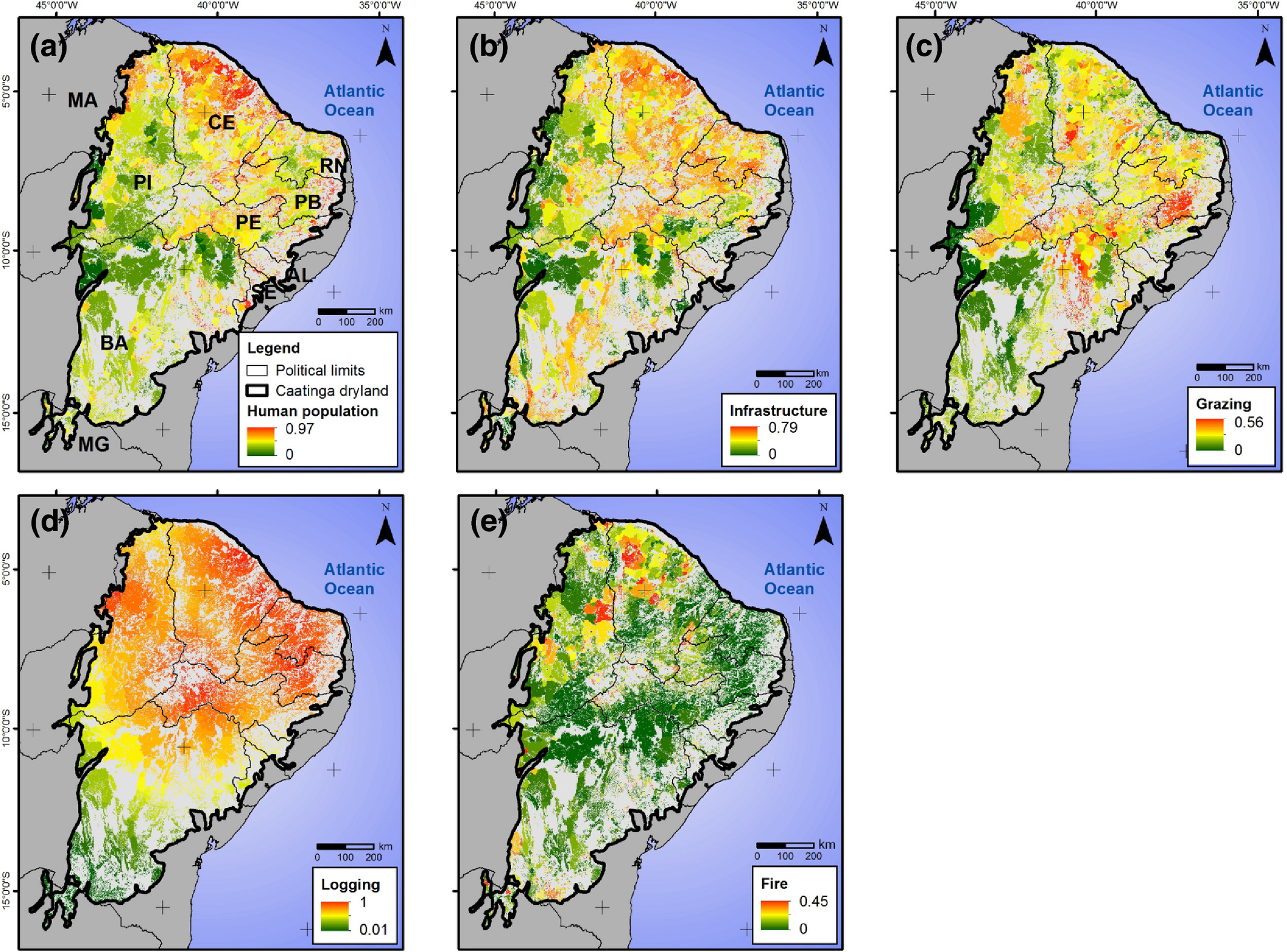 In the image, disturbance vectors are distributed geographically in the Caatinga. (A) represents human population (CDI of 0.64), (B) shows infrastructure (CDI of 0.86), (C) maps grazing (CDI of 0.49), (D) shows wood extraction (CDI of 0.50) and (E) represents fire (CDI of 0.04). Credits: Journal of Applied Ecology, First published: 05 July 2020, DOI:(10.1111/1365-2664.13686)
The researchers, from the Federal University of Rio Grande do Norte (UFRN) and World Resources Institute Brazil, wanted to understand how the intensity of such disturbance varies among different geographic regions, forest fragment sizes, and as a function of distance to the edges of forested areas. They then accounted for the degradation levels they found by using an index, the chronic anthropogenic disturbance index (CDI).
Five elements, or vectors, compose the CDI: human population, infrastructure, grazing, logging, and fire. Each has a different impact in several regions of the Caatinga, and together they account for the disturbance indexes the team found. The CDI goes from 0 to 1, and the higher the index in a specific area, the more degraded it is. The least-disturbed areas were found in the east and central regions of the biome (with forest patches where the CDI was 0.12) and the most degraded areas were in the north of the Caatinga (with a CDI of 0.80).
 Located in Lajes municipality in Rio Grande do Norte state, Serra do Feiticeiro has strong conservation potential. Image courtesy of Juan Carlos Vargas Mena.
The Caatinga alone has a total area of 844,453 square kilometers (524,700 square miles), roughly extending throughout 11% of Brazil’s territory. “Measuring degradation by means of field observation in such a vast area is extremely hard to do,” Carlos Roberto Fonseca, co-author and researcher at UFRN’s ecology department, told Mongabay in a telephone interview. “We wanted to extrapolate results for the Caatinga as a whole, not only observe a few selected spots,” he added.
Fonseca and his colleagues used existing data from several databases — such as the population census by the Brazilian Institute of Geography and Statistics (IBGE), the Brazilian bovine census, and official maps of roads, railways, dams and power lines — to estimate impacts. They then crossed these data with the IBGE census map, which has a pixel grid. The objective was to measure the degradation impact for each pixel of the Caatinga map by measuring the different weights of each vector they calculated.
Degradation is unevenly distributed across the Caatinga, since different regions are under different types of pressure.
“Urbanization and cattle farming have deeply degraded the east coastline along the years, while in the northern portion there is a lot of wood extraction and human settlements, and not all of them are sustainable because of poaching. Some other regions are still preserved and could become conservation areas,” Fonseca said.
 Cacti, thorny bushes and thick-stemmed plants make up most of the vegetation in the Caatinga, which means “white forest” in the Tupi language (caa=vegetation, tinga=white). Image courtesy of Juan Carlos Vargas Mena.
The study, published July 2020 in the Journal of Applied Ecology, shows that smaller Caatinga fragments were very heterogeneous, ranging from being little to highly degraded. Larger patches of vegetation were found to have medium disturbance levels. Infrastructure was the vector found to cause the highest disturbance (with a CDI of 0.86) and fire to cause the lowest (with a CDI of 0.04). The impact of all vectors — human population, infrastructure, grazing, logging, and fire — was highest at the edges of forest patches.
Large works of infrastructure cause immediate and large impacts on the environment. On the other hand, grazing, logging and fire are directly connected to the human presence in remaining vegetated areas and account for a significant part of their chronic degradation.
In a telephone interview with Mongabay, Marcelo Tabarelli, professor at the botanical department at the Center of Biological Sciences of the Federal University of Pernambuco, said that many families who live in the region are highly dependent on natural resources from the Caatinga — and this has been a long historical process that extends into the present. “They extract wood for cooking, for example, and also sell it to nearby small businesses which depend on charcoal for fuel. Their goats and cattle feed on small amounts of vegetation, and such extraction of biomass is small, but continuous,” said Tabarelli, who was not involved in the study.
Tabarelli said these patterns in such a culture of domestic extraction have been largely neglected by ecological research. He said the study is important because it sheds light on an overlooked aspect of a widely unstudied biome. “It shows the remaining forest areas in Caatinga are exposed to wood and fruit extraction, and slash-and-burn agriculture. This kind of nutrient and biomass extraction is part of the local sertanejo culture from traditional communities here in Brazil and in many parts of the world.”
 Cacti, thorny bushes and thick-stemmed plants make up most of the vegetation in the Caatinga, which means “white forest” in the Tupi language (caa=vegetation, tinga=white). Image courtesy of Juan Carlos Vargas Mena.
These chronic disturbance effects also take place in other regions where smaller groups depend exclusively on extraction of natural resources to live, such as the dry forests in parts of Africa and in rural regions of India, Tabarelli added. “As human communities reorganize in these spaces and other species proliferate and adapt to these degraded areas, a process of biological homogenization takes place. In India, for example, this process is more radical and is related to processes of biological invasions and collapse in forest structures over the remaining vegetation.”
Tabarelli said he sees a vacuum in terms of sustainable development planning for the Caatinga. “Environmental degradation is not a byproduct of climate change but will speed up as dryness increases. There is a historical lack of legal measures to effectively tackle Caatinga issues, and the data on desertification are a proof of that,” he said.
Pressure on biomes like the Caatinga will increase with climate change, as droughts and other extreme events become more frequent and cause forests to lose productivity, Tabarelli said.
In this sense, both he and Fonseca stress the need for the creation of conservation areas among the remaining forest regions. “Despite half the Caatinga [being] lost, the connectivity between the remaining vegetation patches is still high, and this is crucial for the animals to go from one place to another,” Fonseca said. He added that in the first decade of the 2000s, “Brazil was moving in an upward spiral — this was when the country created maybe 80% of the world’s conservation areas. The scenario slowed down in the Dilma Rousseff years [2011-2016] and now we’re living with a backlash perspective, risking serious rollbacks in environmental terms.”
Banner image: Some areas in the Caatinga, such as this forest patch in Lajes, Rio Grande do Norte, are well-preserved and have potential to become protected areas. Image courtesy of Juan Carlos Vargas Mena.
Citations:
Antongiovanni, M., Venticinque E. M., Matsumoto, M., Fonseca, C. R. (2020). Chronic anthropogenic disturbance on Caatinga dry forest fragments. Journal of Applied Ecology, 57(10), 2064-2074. doi:10.1111/1365-2664.13686
Silva, J. M., Leal, I. R., Tabarelli, M. (2017). The future of the Caatinga. In Caatinga: The largest tropical dry forest region in South America (pp. 461-474). Springer. doi:10.1007/978-3-319-68339-3_19